
Thursday, July 9, 2026
Monday, July 6, 2026
Chinese Solar Technology for Seawater Desalination
from GoodNewsNetwork.org

New Solar Tech Makes Desalinating Seawater Cheaper Than Producing Bottled Water
A team of materials scientists in China have developed a solar-powered device that can produce freshwater from seawater with better economics than bottled water.
By creating a weave of nanomaterials and organic polymers which were both durable and highly reflective, they created a device that could absorb 90.2% of incoming sunlight and use it to evaporate water with 47.5% less energy.
After it generated 5 gallons of fresh water every day for a year of testing, the scientists say that at scale it would be cheaper than producing bottled water.
It wasn’t a coincidence that after seawater desalination plants were threatened with destruction during the recent war in the Persian Gulf, virtually all belligerents came to the negotiating table. The some-400 desalination plants located along the Gulf’s shoreline represent most of the world’s R&D into the technology, which for decades has been stuck with an energy-intensive process known as membrane or reverse osmosis desalination.
A team of materials scientists in China have developed a solar-powered device that can produce freshwater from seawater with better economics than bottled water. By creating a weave of nanomaterials and organic polymers which were both durable and
Sunday, July 5, 2026
Redhorse Sucker Die-off from Warm Water Temperatures


Saturday, July 4, 2026
Su2026 Biodiversity Blogs
Monday, June 29, 2026
Smithsonian Science Education Center Sustainable Agriculture for Educators

The virtual Smithsonian Science for Global Goals "Agriculture!" Academy will support educators by offering step-by-step guidance and interactive resources to implement our latest community research guide with students and facilitate activities focused on agricultural sustainability.
Through this dual approach, educators will gain insight into integrating interdisciplinary topics into their classrooms from other educators in their cohort, professionals at the Smithsonian Science Education Center, and external collaborators.
By attending this training, you will:
- Learn how to support youth in understanding how agriculture connects to the self and community, and how environmental, economic, cultural, and social systems interact locally and globally. Click Read More to see details nd schedule options.
Monday, June 8, 2026
Zillow trick for studying South Branch river property flooding risk

But as most know, for a specific address, use the FEMA Flood Map Service Center at https://msc.fema.gov/portal/home
Thursday, June 4, 2026

Wednesday, June 3, 2026
State Record Golden Rainbow Trout from the South Branch
This actually happened in early April. I learned about it only today (June!) in West Virginia Magazine. The following is an earlier April 13 article by Bob McNally I found in Outdoor Life Magazine online.
‘Too Fat to Jump.’ West Virginia Teen’s Massive Golden Rainbow Trout Is a Pending State Record
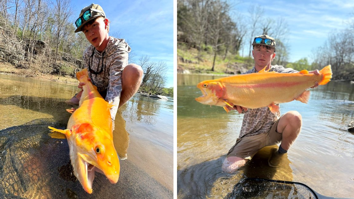
Every spring, West Virginia anglers head out on their own “Gold Rush.” The special two-week event revolves around golden rainbow trout, a unique strain of gold-colored rainbows that are produced in state hatcheries. This year, the West Virginia Department of Natural Resources stocked 50,000 of these trout in 69 lakes and streams. One hundred trout were tagged and worth special prizes.
Fifteen-year-old Hunter Rohr was one of the anglers looking for gold this month. On April 2, during his spring break, he and his high high-school buddy Bryar Sandy were searching for fish in streams near Rohr’s home in Buckhannon.
Read Next: Palomino Trout: The Lure of the Golden Mutants
Rohr and Sandy had started fishing at 7 a.m. that morning. They’d each caught a few smaller golden rainbows and released them all as they usually do. Around noon, they found a pile of fish in a deep hole on the South Branch of the Potomac River.
“We call it the South Branch of the Smoke Hole, and we fish it a good bit,” Rohr tells Outdoor Life. “That day we were using light spinning tackle, four-pound test line and floats to try and catch a golden. We wanted one with a tag.”
The water was deep but clear, and there were some other anglers working the same stretch of water. Using a pair of quality polarized sunglasses, he spotted an especially large fish holding near a log on the bottom.
Click <more> below for more photos.
Monday, May 25, 2026
Cresting just below Action Level (12 feet) this week

Cresting overnight in the early hours Thursday morning?
Watch for changes at the NOAA site:
https://water.noaa.gov/gauges/sprw2
Recreation is hazardous above 5 feet.
At Action Level (12 feet on the Springfield gauge) there is minor flooding on riverside roads and camps, and docks, steps, and canoes and kayaks can be swept away.
Sunday, May 24, 2026
Sustained Rain Overcomes Virginia - West Virginia Drought Concerns
Steady moisture over several days is ideal for recovering from the drought. The whole watershed was affected, and you can see the expected change in the river level.
